Warmer today, frigid temps and wintry weather move in next week

Your News On 6 weather experts are monitoring the latest data to keep you safe and informed.
What to Expect:
📅 Friday: Warmer… Slightly
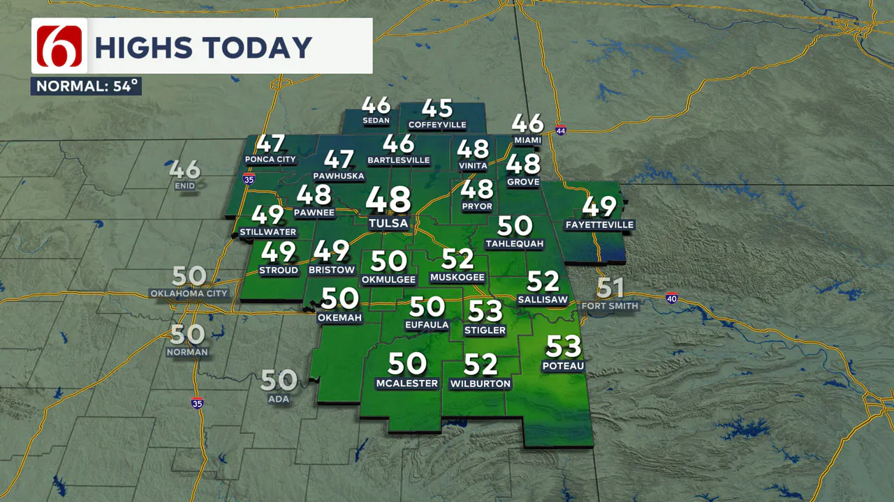
- 🌤️ Morning sun, highs in the upper 40s to lower 50s.
- 💨 Gusty south winds at 15-30 mph.
- ☁️ Increasing clouds through the day.
- 🌧️ A few spotty showers possible late tonight in extreme southeastern OK.
📅 Saturday: A Weather Rollercoaster
- 🌡️ Morning temps climb into the 50s, lower 60s in SE OK.
- 💨 Cold front moves in, dropping temps into the 40s by afternoon.
- 🌧️ Scattered showers possible, mainly across far eastern OK.
- ❄️ Light snow possible in far northeastern OK by evening, but no travel impacts expected.
📅 Sunday: Dry, but Bundle Up!
- 🌡️ Morning lows in the teens, highs only in the lower 30s.
- 🌞 Mostly sunny skies.
- 🌬️ Light north winds, shifting south later in the day.
📅 Monday: The Deep Freeze Begins
- 🌡️ Highs in the upper 40s before an arctic blast arrives.
- 💨 Cold front pushes through by evening, dropping temps into the 20s overnight.
- 🌨️ Chance for wintry mix or freezing rain in southern OK late Monday night.
📅 Tuesday: Winter Weather & Brutal Cold
- ❄️ Wintry precipitation likely, mainly snow across most of OK.
- 🌡️ Morning lows in the mid-20s, highs struggle to reach the lower 20s.
- ⚠️ Freezing rain or mix possible in southern OK early Tuesday.
📅 Mid to Late Week: Arctic Lockdown
- 🥶 Sub-freezing temperatures continue.
- 🌡️ Temps stay below freezing until at least Friday in southern OK, Saturday in northern OK.
Tracking More Cold Air and Wintry Impacts
Afternoon highs will reach the upper 40s and lower 50s with increasing clouds and gusty south winds today before our next cold front rapidly moves across the area on Saturday.
This system brings a slight chance for a few showers across eastern Oklahoma that could change into some light snow across far northeastern OK Saturday evening.
Colder air is expected Saturday night and Sunday. A much stronger cold front will approach the area Monday afternoon and Monday night, bringing the coldest air of the season.
Additionally, the potential for wintry weather impacts will increase with the Tuesday system.
Any Rain Tonight?
Rain is not expected for most locations tonight. As our first storm system organizes to the west, our pressure gradient strengthens.
This means gusty south winds return at 15 to 30 mph this afternoon with mostly to partly cloudy conditions noted across eastern Oklahoma.
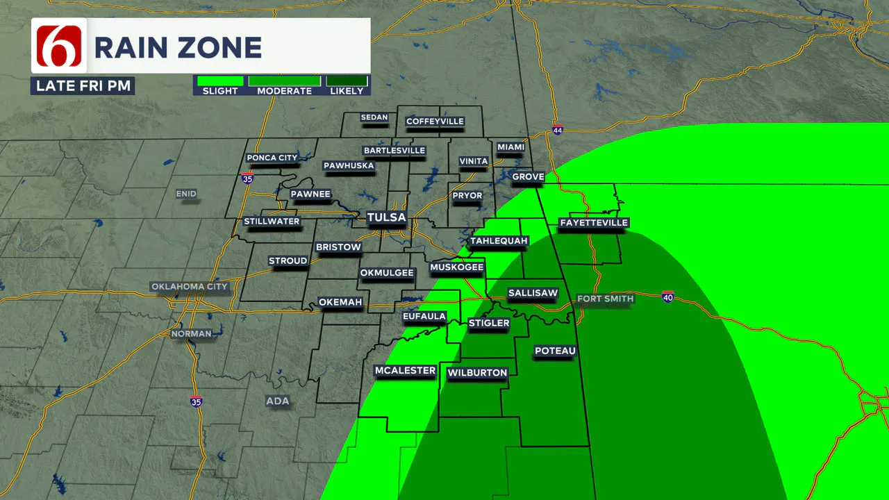
Later tonight, a few spotty showers or storms will start to develop across extreme southeastern Oklahoma. Most of this activity will remain southeast of the Tulsa metro, but a few showers and storms will be possible along and east of Highway 69 and south of the I-40 corridor.
What Happens Saturday?
Saturday morning, the main upper-level trough approaches the state as a surface area of low pressure develops along a cold front progressing to the south. Locations ahead of the front will see temperatures rising into the lower 50s.
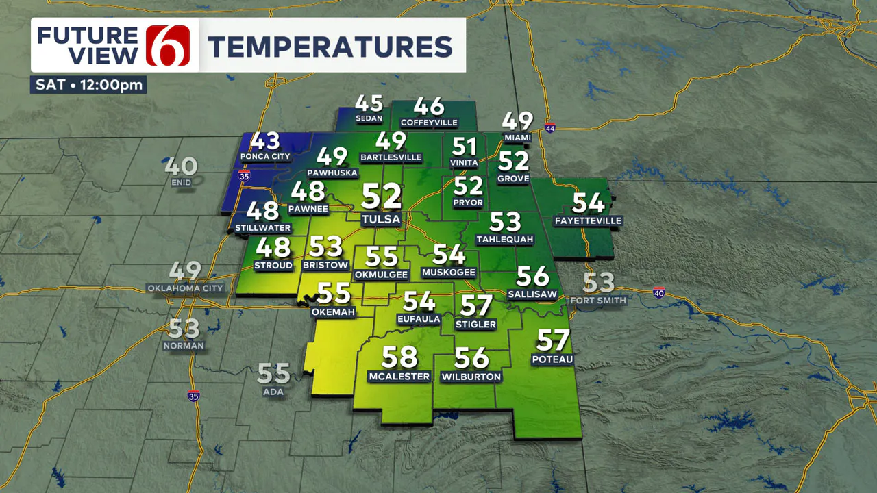
As the front passes the area, temperatures will quickly drop into the lower 40s by later Saturday afternoon.
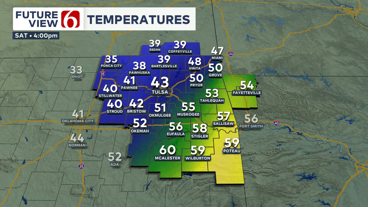
The timing of the cold front may change, and this may have an impact when the colder weather arrives. Southeastern OK will see afternoon highs reaching the lower 60s before falling temperatures arrive around sunset.
How's the rain-snow chance for Saturday?
A few showers or storms will be possible Saturday, but higher probabilities will remain across far eastern sections of the state. This storm system is very dynamic and could bring a dry slot across portions of central Oklahoma by early afternoon.
This means the probability for measurable precipitation will be lower from Oklahoma City to Tulsa and slightly higher across extreme sections of the area.
As the cold front exits eastern Oklahoma, strong to severe storms will develop across portions of southern Arkansas, Louisiana, Mississippi, and Alabama.
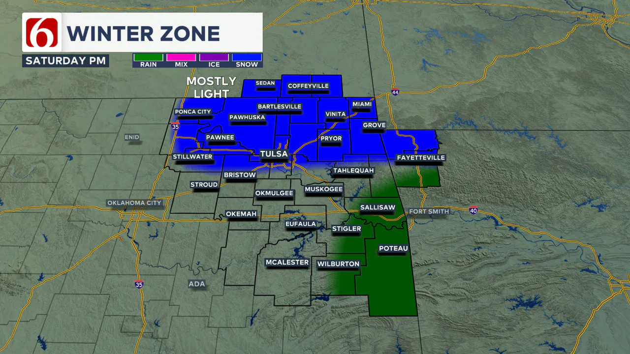
As colder air filters in behind the departing cold front, any leftover moisture will have a chance to become light snow Saturday evening along and north of Highway 412.
No Travel impacts are expected but a few locations may see a dusting of snow across northeastern OK, southeastern Kansas, and Northwestern Arkansas.
Do I Need Rain Gear Sunday
No. It will be dry. But you do need your big coat. A surface ridge builds across the central part of the country, bringing chilly weather on Sunday.
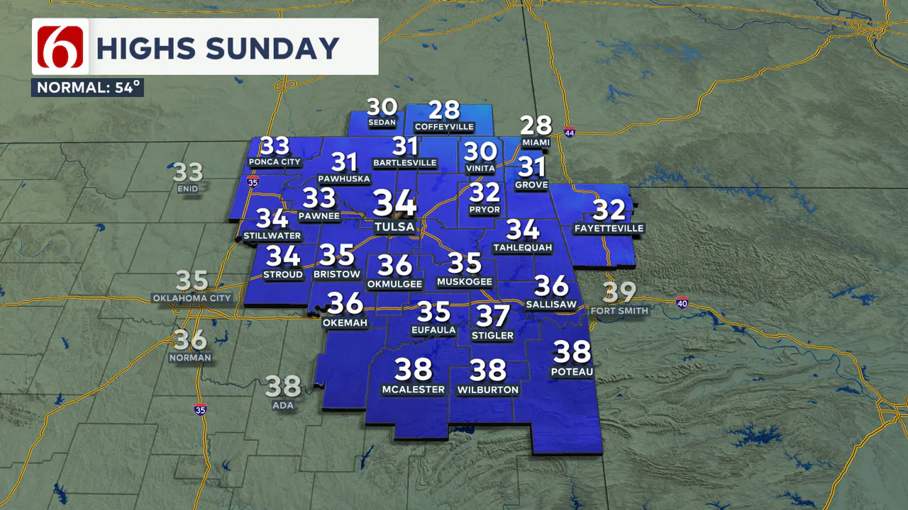
Morning lows will start in the teens and daytime highs will only reach the lower 30s. We should have mostly sunny conditions with a light north wind early and a south wind later in the afternoon at less than 10 mph.
I'm Seeing Things on Social About Another Winter Storm next week?
Yes, you’ll see a lot of chatter about this system. First up, extremely cold air will arrive, and secondly, there is a chance for more wintry weather impacts. We're still a few days out and things can and do change, but the probability for cold air is very high and the probability for some wintry impacts is growing.
The stronger storm system arrives Monday evening and early Tuesday with plummeting temperatures. This air mass will be the coldest of the season. Additionally, most data support the potential for wintry weather impacts with this storm system.
Monday's high temperatures should reach the upper 40s or even the lower 50s before plummeting Monday evening into the 20s.
Tuesday morning will start in the mid-20s, with daytime highs only in the lower 20s. This is technically a shallow air mass and it’s expected to progress far enough south to bring deeper cold air across most of Oklahoma by early Tuesday.
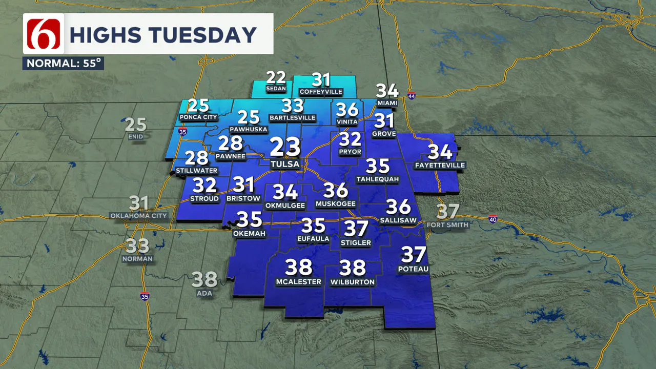
This means the predominant wintry precipitation type should be snow. There will be a probability of some freezing rain or wintry mix along the leading edge of the cold front as it approaches the area early Tuesday morning.
Specific locations of a mixed zone of precipitation seem more likely across southern Oklahoma based on today's data. But this portion of the forecast regarding this zone of mixed precipitation will more than likely change over the next few days.
How Long will we be in the deep Freeze?
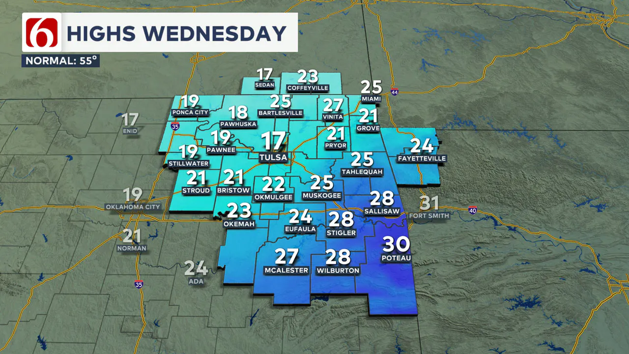
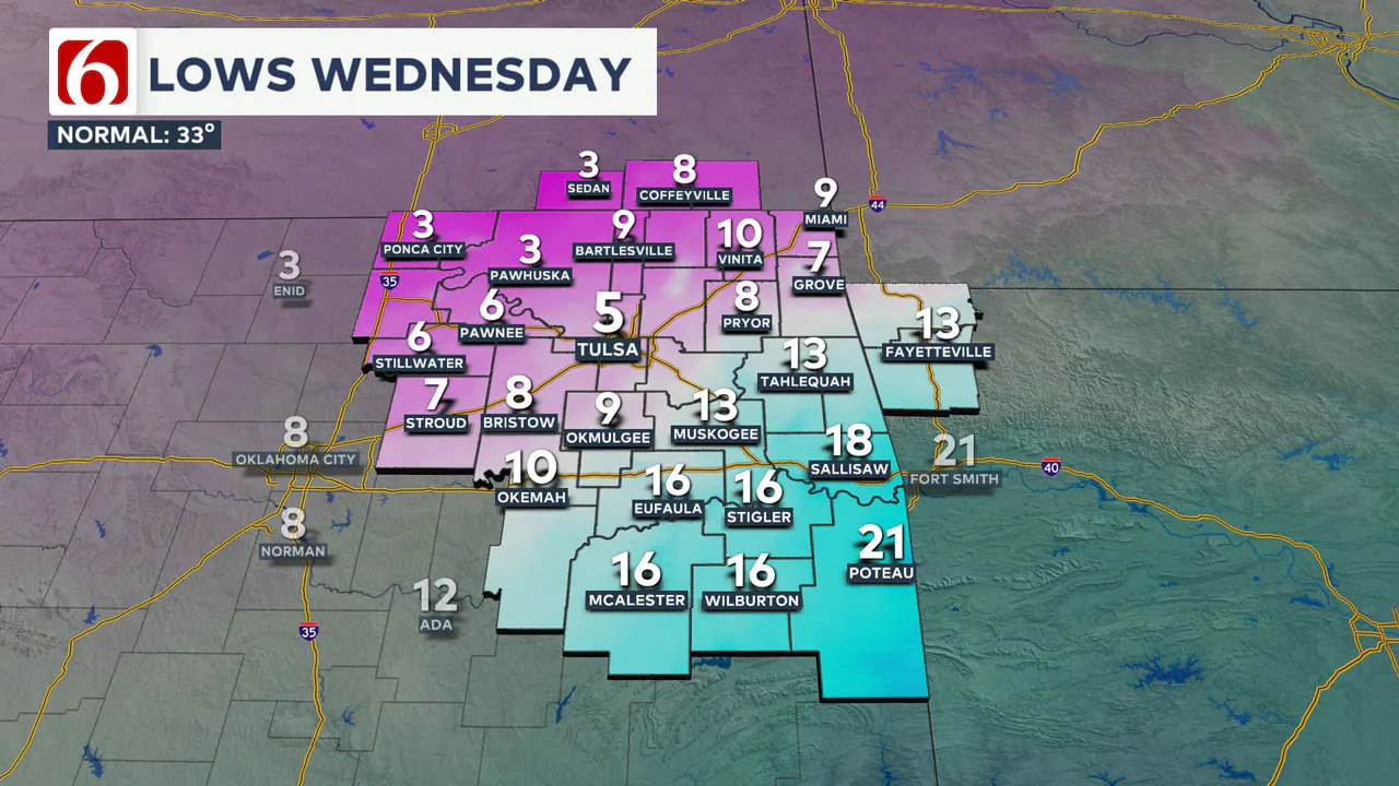
The duration of the Arctic air mass is expected to remain for the rest of the week. Once we drop below freezing by Monday evening, we are expected to stay below freezing until either Friday for southern OK and Saturday for the northern sections of the state.
———
Winter Weather Preparation:
Where are the warming shelters available in Tulsa this year?
The city of Tulsa, local shelters, warming stations, and outreach teams are working to ensure access to safe, warm spaces during the cold temperatures.
>>> City of Tulsa prepares for extreme cold temperatures
>>> Warming Shelters Open Across Tulsa Amid Freezing Temperatures
Tulsa shelters and temporary warming locations are open to provide refuge. Major locations include:
- John 3:16 Mission, 506 N. Cheyenne — Open 24/7
- The Salvation Army Center of Hope, 102 N. Denver Ave. — Open 24/7
- Tulsa Day Center, 415 W. Archer St. — Open 24/7 (Pets allowed, limited capacity)
>>> Center Of Hope Expands Services During Freezing Temperatures
Temporary overflow shelters will also be open for the cold weather:
- The Merchant: 605 S. Peoria Ave., open Monday, Jan. 20, 9 a.m.–Noon; Tuesday-Friday, 9–11 a.m.
- Denver Avenue Station: 319 S. Denver Ave., open Sunday, 8:30 a.m.–8:30 p.m.; Monday-Saturday, 5:30 a.m.–11:30 p.m.
- The Station at Youth Services: 311 S. Madison Ave., open Monday-Friday, 11 a.m.–4 p.m.
- Iron Gate: 501 W. Archer St., open daily, 8:30–10:30 a.m.
- The Ministry Center: 312 S. 33rd W. Ave., open Tuesday-Thursday, 9:30 a.m.–1 p.m.
For a full list of warming station locations and hours, visit Housing Solutions’ Winter Weather Information Page.
>>> Warming Shelters, Safety Tips For Cold Temperatures This Winter In Oklahoma
>>> Tulsa Clinic Offers Health Care Services At Warming Shelters
Bring Pets Inside!
Winter temperatures can pose additional challenges for pets, particularly older animals or those with health conditions. Hartfield recommends:
- Wellness Checks: Ensure pets are up to date on vaccines and discuss arthritis or other cold-weather health concerns with a veterinarian.
- Outdoor Time: Monitor the duration of outdoor activities, especially for short-haired breeds or pets with conditions like diabetes or heart disease.
- Paw Care: After walks, inspect and clean paws to remove ice or de-icing chemicals that could harm your pet.
>>> Cold Weather Pet Tips: How To Keep Animals Safe During Winter Months
How Can I Protect Myself From Sickness Or The Flu This Winter?
The Tulsa Health Department is urging residents to receive flu and COVID-19 vaccinations to prevent respiratory illnesses as Oklahoma enters the coldest months of the year.
>>> What You Can Do For Your Kids To Prevent The Flu Amid Rise In Cases
- Health experts say the risk of respiratory illnesses is higher during the winter, as colder weather often leads to more indoor gatherings, increasing the likelihood of viruses spreading.
- The Centers for Disease Control and Prevention says Oklahoma is one of 11 states with very high respiratory virus activity, and with flu vaccination rates lower than this time in 2024, more people have reported getting sick.
>>> How to Protect Yourself From Respiratory Illness This Winter
>>> Districts Are Cautiously Optimistic As Attendance Rate Begin To Rise
>>> 3 Things Doctors Want You To Know About The Flu In Oklahoma
Emergency Info: Outages Across Oklahoma:
Northeast Oklahoma has various power companies and electric cooperatives, many of which have overlapping areas of coverage. Below is a link to various outage maps.
>>> Tulsa HVAC, Plumbing Companies Flooded With Calls During Cold Weather
- PSO Outage Map
- OG&E Outage Map
- VVEC Outage Map
- Indian Electric Cooperative (IEC) Outage Map
- Oklahoma Association of Electric Cooperatives Outage Map — (Note Several Smaller Co-ops Included)
The Alan Crone morning weather podcast link from Spotify:
https://open.spotify.com/episode/5UQckZKm7uaaMqS3x90Zz6
The Alan Crone morning weather podcast link from Apple:
Follow the News On 6 Meteorologists on Facebook!
- Meteorologist Travis Meyer
- Meteorologist Stacia Knight
- Meteorologist Alan Crone
- Meteorologist Stephen Nehrenz
- Meteorologist Aaron Reeves
- Meteorologist Megan Gold
