Colder air returns to northern Oklahoma with temperature swings ahead

Colder Air Returns
Colder air has returned to most of northern Oklahoma today. A shallow cold front will continue to move back and forth across the region for the next several days, resulting in wide temperature swings from north to south and west to east.
Light precipitation, mostly in the form of drizzle or mist, is possible this afternoon and tonight near and north of the I-40 corridor.
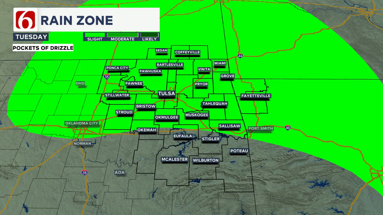
Temperatures tonight into early Wednesday morning should remain above freezing for our immediate area.
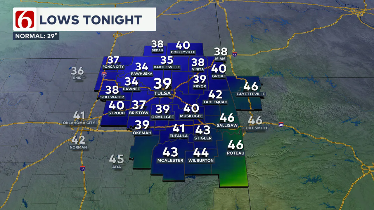
How Much of A Cool-Down Today?
A shallow modified Arctic air mass moved across part of Oklahoma overnight and is continuing to slide southward.
This will bring colder weather today to the northern third of the state compared to yesterday’s record highs.
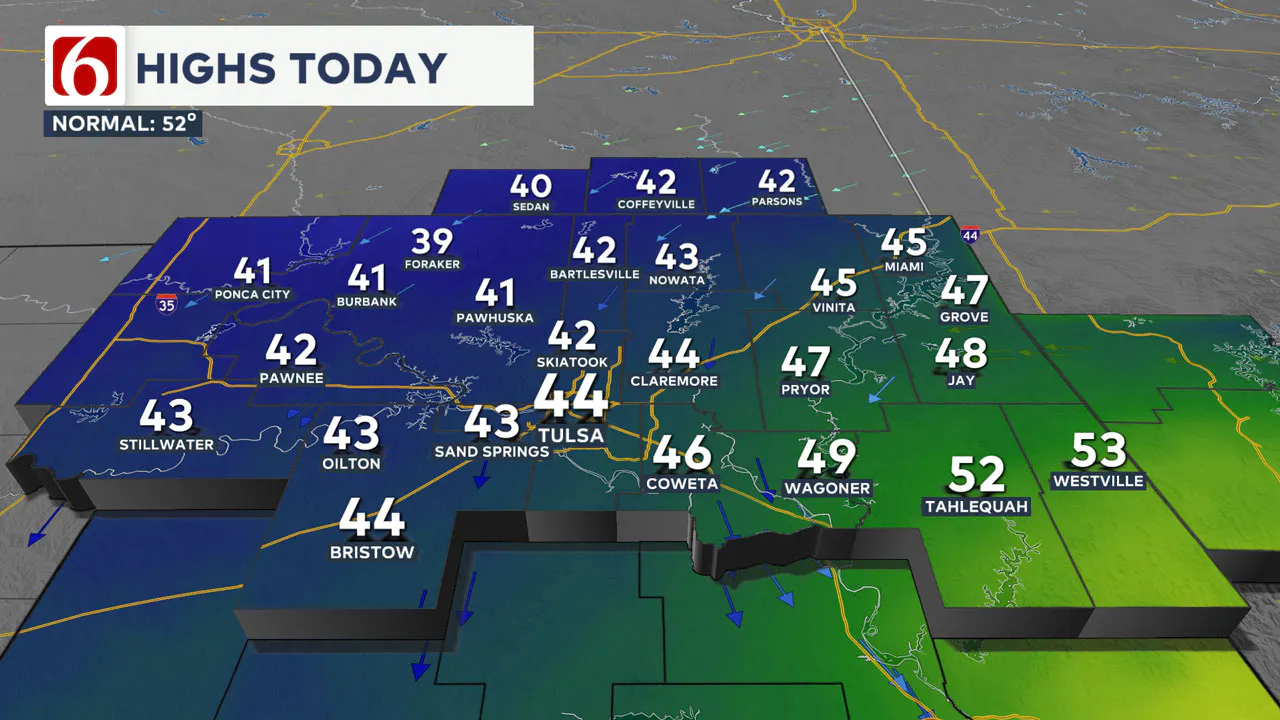
Southeastern and East Central Oklahoma will experience cooler weather than yesterday, but temperatures will remain higher than those in the northern sections due to the shallow nature of the air mass.
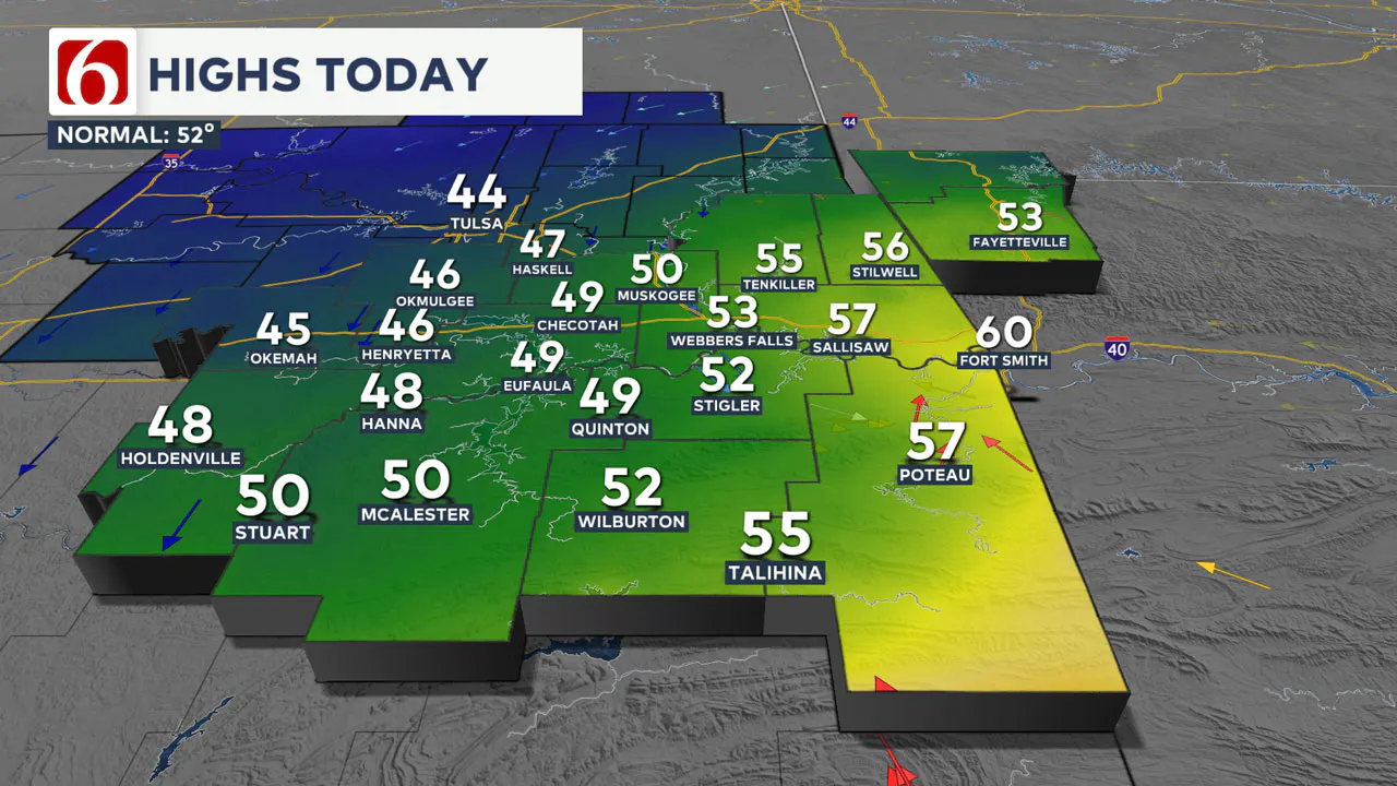
Highs this afternoon in the northern sections will stay in the lower 40s, while southeastern Oklahoma will reach the lower to upper 50s.
North winds will continue at 10 to 15 mph throughout the day.
Any Precipitation With This System?
Later tonight, the boundary is expected to slide slowly north as a quasi-retreating warm front. Above the shallow layer of cold air, south winds will bring warmer air up and over the region.
A weak disturbance in the zonal flow will trigger the chance for drizzle developing this afternoon and tonight near and north of the boundary, with the possibility of very light showers before dawn Wednesday across extreme northeastern Oklahoma, southeastern Kansas, and southwestern Missouri.
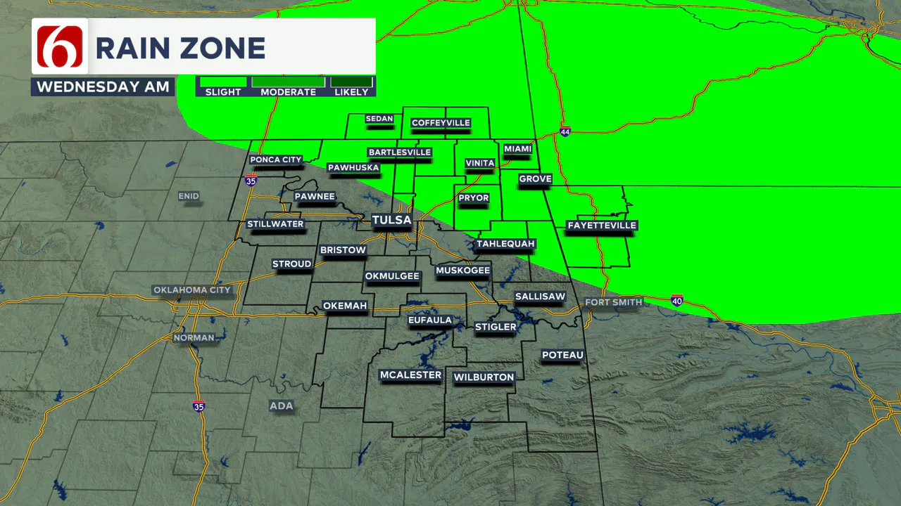
The probability for measurable precipitation remains near or less than 10% for most of the area, but nuisance precipitation is likely across northern sections of the state into southern Kansas later this evening.
How Long Will This Pattern Last?
This pattern will continue for most of the week. The same front will move southward again Wednesday night into early Thursday before retreating north once more on Friday.
This cycle will continue into the first part of the weekend before the upper airflow shifts, allowing a stronger push of the shallow cold air mass southward.

This will bring much colder weather by Sunday, which is expected to last for several days, possibly throughout the entire next week.
As the upper airflow changes, a disturbance in the southern stream will create the potential for precipitation, including the possibility of wintry weather Tuesday through Thursday.
Although models offer varying solutions, ensemble data generally supports this scenario.
Specific changes will be made as we approach early next week, but the overall pattern suggests a return of cold weather and wintry precipitation chances.
Forecast Challenges
The temperature forecast for both today and tomorrow has a higher margin of error due to the shallow nature of the air mass.
Forecast variables for most of northern Oklahoma have been lowered today and may need further adjustments for Wednesday’s high temperatures.
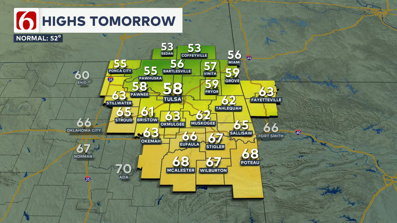
Essentially, what happens today will directly influence tomorrow’s forecast.
The shallow nature of the leading edge of the colder air makes it difficult for these air masses to penetrate the varied terrain of extreme eastern and southeastern Oklahoma.
If the air were deeper, the entire region would support colder weather.
However, we expect the leading edge to remain very shallow, which typically halts its southward movement as it encounters the Kiamichis, the Jack Forks, and extreme eastern Oklahoma into western Arkansas.
Consequently, in this pattern, temperature gradients can vary greatly over short distances, particularly in the far eastern and southeastern sections of the state.
———
Winter Weather Preparation:
Where are the warming shelters available in Tulsa this year?
The city of Tulsa, local shelters, warming stations, and outreach teams are working to ensure access to safe, warm spaces during the cold temperatures.
>>> City of Tulsa prepares for extreme cold temperatures
>>> Warming Shelters Open Across Tulsa Amid Freezing Temperatures
Tulsa shelters and temporary warming locations are open to provide refuge. Major locations include:
- John 3:16 Mission, 506 N. Cheyenne — Open 24/7
- The Salvation Army Center of Hope, 102 N. Denver Ave. — Open 24/7
- Tulsa Day Center, 415 W. Archer St. — Open 24/7 (Pets allowed, limited capacity)
- Youth Services of Tulsa, 311 S. Madison Ave.
Temporary overflow shelters will also be open for the cold weather:
- The Merchant: 605 S. Peoria Ave., open Monday, Jan. 20, 9 a.m.–Noon; Tuesday-Friday, 9–11 a.m.
- Denver Avenue Station: 319 S. Denver Ave., open Sunday, 8:30 a.m.–8:30 p.m.; Monday-Saturday, 5:30 a.m.–11:30 p.m.
- The Station at Youth Services: 311 S. Madison Ave., open Monday-Friday, 11 a.m.–4 p.m.
- Iron Gate: 501 W. Archer St., open daily, 8:30–10:30 a.m.
- The Ministry Center: 312 S. 33rd W. Ave., open Tuesday-Thursday, 9:30 a.m.–1 p.m.
For a full list of warming station locations and hours, visit Housing Solutions’ Winter Weather Information Page.
>>> Warming Shelters, Safety Tips For Cold Temperatures This Winter In Oklahoma
Bring Pets Inside!
Winter temperatures can pose additional challenges for pets, particularly older animals or those with health conditions. Hartfield recommends:
- Wellness Checks: Ensure pets are up to date on vaccines and discuss arthritis or other cold-weather health concerns with a veterinarian.
- Outdoor Time: Monitor the duration of outdoor activities, especially for short-haired breeds or pets with conditions like diabetes or heart disease.
- Paw Care: After walks, inspect and clean paws to remove ice or de-icing chemicals that could harm your pet.
>>> Cold Weather Pet Tips: How To Keep Animals Safe During Winter Months
How Can I Protect Myself From Sickness This Winter?
The Tulsa Health Department is urging residents to receive flu and COVID-19 vaccinations to prevent respiratory illnesses as Oklahoma enters the coldest months of the year.
- Health experts say the risk of respiratory illnesses is higher during the winter, as colder weather often leads to more indoor gatherings, increasing the likelihood of viruses spreading.
- The Centers for Disease Control and Prevention says Oklahoma is one of 11 states with very high respiratory virus activity, and with flu vaccination rates lower than this time in 2024, more people have reported getting sick.
>>> How to Protect Yourself From Respiratory Illness This Winter
Emergency Info: Outages Across Oklahoma:
Northeast Oklahoma has various power companies and electric cooperatives, many of which have overlapping areas of coverage. Below is a link to various outage maps.
>>> Tulsa HVAC, Plumbing Companies Flooded With Calls During Cold Weather
- PSO Outage Map
- OG&E Outage Map
- VVEC Outage Map
- Indian Electric Cooperative (IEC) Outage Map
- Oklahoma Association of Electric Cooperatives Outage Map — (Note Several Smaller Co-ops Included)
The Alan Crone morning weather podcast link from Spotify:
https://open.spotify.com/episode/3JfGruRuIh98PRcYSxImQM
The Alan Crone morning weather podcast link from Apple:
Follow the News On 6 Meteorologists on Facebook!
- Meteorologist Travis Meyer
- Meteorologist Stacia Knight
- Meteorologist Alan Crone
- Meteorologist Stephen Nehrenz
- Meteorologist Aaron Reeves
- Meteorologist Megan Gold
